

How to solve the traffic problem in Indian cities.
How to solve the traffic problem in Indian cities.

City is a cluster of hundreds of 4 km radius localities or neighborhoods. So a mega city like Bangalore may be having around 200 such localities. People live in one of these and go to work in another predominantly.
Most of these were villages annexed to make it a mega city over time organically. So they are not well planned in terms of roads, footpaths, schools, hospitals, playgrounds, parks and so on. Only few localities have been planned and laid out.
The main issues for citizens living in a locality that is not planned or travelling through one for whatever reason is the narrow roads filled with cars or two wheelers and long body buses and some trucks as well. Its a mess in every area during peak hours when people crisscross these places.
People who live there have to bear the noise, pollution, risk of walking, traffic jams and all the ill effects caused by these like lack of sleep, decline in productivity, mobility etc.
To begin with we need less vehicles on the roads.
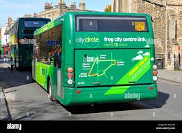
Reliable, predictable, frequent, cost effective public transport both long body and short body buses connecting every part of a neighborhood along with bicycle lanes for people to cover last mile as they get down from their bus or small vehicles to ferry them will make people shift from using their own vehicles.
This bus network should seamlessly connect with MRTS or suburban trains to make it very effective to use this network.
Imagine people are like packets in a TCP / IP network (or the internet). Packets you send by typing a mail traverse from your computer to the gateway in the local network to which it is connected, from where it goes to the routers to which the local networks connect and go out of a country’s gateway connecting to other countries via wide area networks over satellites or under sea cables.
The protocols used in routing finds the most efficient path to reach the destination.
Going from one point in the city to another point is like routing a person via the most efficient path.
If we can design predictable public transport networks, you can treat a person stepping out of their house to reaching a destination as a case of finding the best route at any point in time and be able to update in real-time.
A person can be given a path on the map of this public transport network to travel and transit at different points with instructions that to follow similar to the navigation done with a map.
It works like this for me.
‘ walk straight for 200 m’
‘take left and wait in the bus stop for 5 mins’
…after 5 mins. a bus comes and stops.
‘board this bus now’
….after half hour of bus ride, the bus stops somewhere.
‘get down here’
‘take the sky walk and enter the metro train station’
…navigates you to the platform
…when a train arrives
‘now get into this train and sit here’.
….after 20 mins of train ride.
‘get down here’
…and finally after more navigation instructions.
‘your destination is on the left’
Voila…you reached your Dentist on time :-)